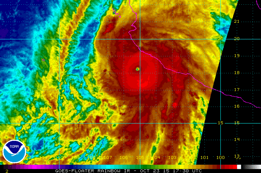
The most powerful hurricane ever recorded in the eastern Pacific will make a "potentially catastrophic landfall" in southwestern Mexico Friday, the National Weather Service says. Hurricane Patricia is bringing winds that now top 200 mph; it's expected to strike Friday afternoon or evening.
"This is the equivalent of a giant EF5 tornado spinning over the Pacific Ocean," says meteorologist Travis Herzog of ABC-13 TV in Houston. "If Patricia maintains anything near this intensity at landfall in Mexico today, it will be unimaginably catastrophic."
Putting the storm in historic perspective, NPR's Russell Lewis compares its size to 1992's Hurricane Andrew, saying, "Patricia is a 'small' storm — the most powerful winds don't extend very far beyond its eye, perhaps only about 30 or 40 miles."
Update at 3:24 p.m. ET: Most Powerful Hurricane In Our Hemisphere
"Warm water from this year's El Nino has turned this hurricane into a monster," NPR's Geoff Brumfiel reports for our Newscast unit. "The National Oceanic and Atmospheric Administration says it is the strongest hurricane ever recorded in the Western Hemisphere."
Going by the World Meteorological Organization's database, Patricia is packing the strongest winds ever measured in a tropical cyclone.
Ben Kirtman of the University of Miami tells Geoff that anyone in this storm's path should get out of the way – a task that's complicated by Patricia's rapid growth since it was first declared a hurricane early Thursday.
"This one looks to me like it blew up overnight," Kirtman says.
Update at 11:45 a.m. ET: Strongest Winds In Small Area
From a Hurricane Center update: "At this time, the Category 5 winds are occurring over a very small area near the center - about 15 miles across. A NOAA Hurricane Hunter aircraft is scheduled to investigate Patricia before landfall to see what changes in intensity and structure have occurred."
Our original post continues:
When it makes landfall, forecasters believe Patricia will be on a north-northeast track — sending it over Mexico and into southern Texas, where it could bring dangerous amounts of rain in a short period of time over the weekend.
The Category 5 storm has forced evacuations in Puerto Vallarta and other areas along Mexico's coast. Forecasters say that in addition to destructive winds, Patricia could bring dangerous flash flooding and mudslides.
Fears about the hurricane's possible impact forced an entire wedding party to leave the Villa Amor hotel in Sayulita, Mexico, north of Puerto Vallarta, in the early hours of Friday morning. The hotel's general manager, Norma Adams, tells All Things Considered:
"I am sitting here at the front desk, and I see nobody on the beach. Our fishermen have brought the boats up all the way to the top of the sandy area. They also said 'No, it's not gonna hit' — but seeing them pull the boats up, you know something's coming."

Adams also sent a photograph from a main roadway, where cars clogged the northbound lane — heading away from Patricia's projected landing point.
A hurricane warning is in effect from San Blas, a town nearly 100 miles north of Puerto Vallarta, to Punta San Telmo, more than 300 miles to the south. The storm was moving at 10 mph, according to the latest data from the National Hurricane Center.
"Patricia is expected to produce total rainfall accumulations of 8 to 12 inches, with isolated maximum amounts of 20 inches," the National Hurricane Center says, "over the Mexican states of Nayarit, Jalisco, Colima, Michoacan and Guerrero through Saturday."
The center adds that the storm will also bring "an extremely dangerous storm surge" to its landfall site.
"After landfall, a combination of the mountainous terrain of Mexico and increasing shear should cause the cyclone to rapidly weaken," the National Hurricane Center says, "with the system likely to dissipate completely after 36 hours."
Copyright 2020 NPR. To see more, visit https://www.npr.org.


